
HISTORIC HURRICANES


Damage to the Battery after the Hurricane of 1911 (Image: Historic Charleston Foundation, 1911)
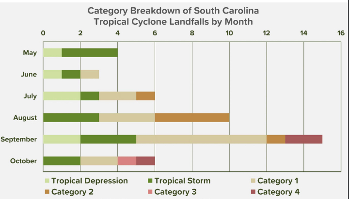
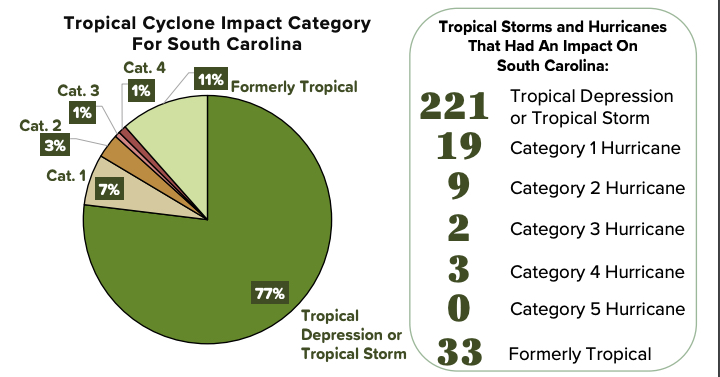
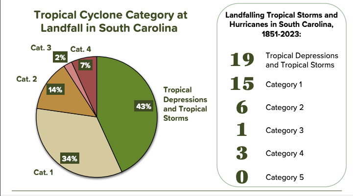
By the numbers (Source: SCDNR, May 2024):
- 286 tropical or formerly tropical cyclones have impacted South Carolina
- 133 storms have tracked through South Carolina
- 44 tropical cyclones have made landfall along the South Carolina coast
- 31 of those storms were Category 1 hurricanes or higher
- 25 hurricanes have made landfall on the South Carolina coast
- 5 cyclones that rated Category 3 or higher have impacted South Carolina
- 4 hurricanes rated Category 3 or higher have made landfall in South Carolina

Even before Charleston’s first permanent European settlers arrived in 1670, tropical storms played a role in our region’s historical narrative. Two years after Christopher Columbus founded his colony on Hispaniola in 1493, it was leveled by a violent storm Caribbean natives believed was sent by an evil spirit named Uracan (sometimes spelled Juracán). Spanish settlers began calling such storms hurricáns, from which we derive the word hurricane.
NOAA’s website lists no fewer than 76 storms that have passed over or by Charleston in the 354 years since the colony was settled, 30 of them major. The S.C. Department of Natural Resources and other historic sources cite letters and reports that tell of storms that don’t appear on NOAA’s list, so the exact number is dictated by what variables one uses to define a tropical cyclone in the Charleston/Lowcountry/state area.
Below are recollections of the storms that either came ashore in or affected the Lowcountry.
Hurricane of Spanish Repulse, 1686
Six years after moving to the peninsula, Charlestonians awoke at daybreak on Sept. 5, 1686, to what was probably their first major hurricane. Roofs were damaged, and trees toppled into flooded streets along the Cooper River waterfront. Ships were blown ashore, and casualties, both human and among livestock, were referenced in ltetters, though with few details.
Yet this storm, often referred to as the Hurricane of Spanish Repulse, had a silver lining: it staved off what might have been an even bigger threat to the young colony – for as it approached Charles Town's coastline, three Spanish ships from St. Augustine were on their way to attack the new English colony.
Having burned and looted the small Scottish settlement of Stuart Town near Beaufort, as well as a few English settlements on Edisto Island, the Spaniards had just set sail for Charles Town when the storm’s powerful winds nearly destroyed their ships. They limped back to Florida, and the Charles Town colony was saved.
Hurricane of the Rising Sun, 1700
The Hurricane of the Rising Sun struck Charles Town shortly before high tide on Sept. 14, 1700. The storm draws its name from an 800-ton ship that failed to make it into Charles Town’s harbor before the storm hit, foundering outside its bar. About 100 souls onboard perished.
In Lowcountry Hurricanes: Three Centuries of Storms at Sea and Ashore, author Walter J. Fraser includes first-person accounts that give an idea of the storm’s force. In a letter written by immigrant Edward Hyrne “... a most terrible Storm of Wind or Hurricane … Thousands of Trees have been torn up by ye Roots, many Houses blown down & more damnified… but ye greatest & most deplorable Loss of all was that of a great Scotch Ship called ye Rising-Sun.”
The winds and waves tore the ship to pieces, leaving the corpses of those aboard strewn along the beaches of Folly and Morris islands. Some credit this incident with Folly Beach having been named “Coffin Island” on early maps.
1713
A major hurricanes in 1713 caused extensive damage when it made landfall north of Charleston, destroying part of the city’s defensive wall, the look-out tower on Sullivan’s Island, and the new St. Philip’s Church, which was under construction. More than 70 deaths were recorded.
1728
The hurricane of 1728 next struck the city at the height of a yellow fever epidemic, leaving, as one contemporary wrote, Charles Town’s streets “covered with boats, boards, staves; and the inhabitants were obliged to take refuge in the higher stories of their dwelling-houses … Twenty-three ships were driven ashore, most of which were either greatly damaged or dashed to pieces.”
1730
Two years after the storm of 1728, another storm damaged ships, buildings, and rice fields, including destruction of the Baptist Church.
Great Hurricane of 1752
The Great Hurricane of 1752 was probably the worst hurricane to ever hit Charleston in recorded history. Eyewitness accounts indicate the storm drove about 17 feet of water through city streets. All but one of the ships moored in the harbor came crashing ashore.
The South Carolina Gazette wrote that the storm “has reduced this Town to a very melancholly situation,” adding that at one point during the storm, “many of the people being already up to their necks in water in their houses, began now to think of nothing but certain death.” Had the wind not shifted, “every house and inhabitant in this town, must, in all probability, have perished.”
The Gazette concluded: “We have daily such a Number of melancholy Accounts from all Parts of the Country, of the Damage sustained on the 15th and 30th [of last month] that they would afford endless Matter for this Paper, were we to publish them.
1783
This strong hurricane tracked along the South Carolina coast causing significant property damage, but not as much flooding as the 1752 storm.
1797
Though a modest-sized hurricane that made landfall Sept. 5 in North Carolina, as it passed by Charleston this storm caused significant damage to the new Battery seawall as powerful waves undermined its foundation.
1800
Charlestonians had barely cleaned up and repaired the Battery seawall when the next tropical storm hit Charleston in 1797, this storm also caused waves to crash over the new Battery seawall, causing extensive damage to it.
1804
This large, violent hurricane probably would have ranked as a Category 3 or 4 as it moved north along the Georgia coastline toward southern South Carolina from Sept. 6-8. Though it most likely made landfall before reaching Charleston, it produced significant wind and water damage around the Lowcountry and killed hundreds.
In his Time Machine podcast, Dr. Nicholas Butler quotes from three contemporary newspapers describing the storm.
From the Charleston Courier, Sept. 10, 1804: “A storm which it is said has not been equaled within the memory of any citizen of Charleston, commenced on Friday evening last, accompanied with very high wind from the North-East, and continued without any considerable abatement, till one o’clock [Sunday] morning. . . . There is not a wharf in the city that has not experienced the dreadful effects of the storm, and some to a very great degree. Many buildings were thrown down, and many others much injured; some of the streets were covered with the slate and tile which were torn from the roofs of the houses; great numbers of the trees which ornamented the city, are destroyed, and the havoc generally made is almost beyond description.”
From the Charleston Times, Sept. 10, 1804: “New East Bay Street, which, since the gale in October 1800, has been repaired at a great expense, is again destroyed; the sea made clear breaches through it, and rushing into Water-street, and the adjacent parts, compelled the inhabitants to quit their houses, in the lower stories of some of which the water was 14 inches deep. In this part of the city, we state from actual observation, that the tide rose three feet higher than it has ever been known since the hurricane of 1752; and several feet higher than the usual spring tides—the whole of Water-street was covered, and in Meeting-street it was nearly two feet in depth.”
“The whole of [South Bay Street] from Meeting-street to McKenzie’s wharf [, near Legare Street,] is washed away. . . . The tide rose so high, that most of the inhabitants quit their houses, and took shelter in a more central part of the city—Two or three small coasting vessels were here driven to pieces. . . . In the vicinity of the city, the gardens have sustained considerable injury—the fences were blown down—large trees torn up by the roots; and the vegetation appears blasted by the salt spray. . . . But few lives were lost in the gale.”
From the Charleston City Gazette, Sept. 10, 1804:: “Great apprehensions were entertained for the safety of the families on Sullivan’s Island, but accounts received from thence yesterday, were very favorable, not a life was lost there except a black boy. From fifteen to twenty houses were undermined by the water and washed away; the inhabitants of which lost almost everything that was in them. It is the opinion of some gentlemen who were on the island and who came up yesterday, that if the water had continued to rise for half an hour longer, scarcely a house would have escaped and many people must have perished.”[3]
1811
This hurricane made landfall Oct. 6 south of Charleston, spinning off a tornado that caused a lot of damage in the city.
1813
This brief, but violent, hurricane came ashore Aug. 27 causing significant property damage and storm surge flooding similar to the 1752 storm and worse than the 1804 storm.
1822
This likely Category 3 storm made landfall Aug. 27 just north of Charleston, producing severe damage, mainly around the Santee River.
1853
The latest Category 1 on record in South Carolina came ashore Oct. 20.
The Great Carolina Hurricane of 1854
This storm made landfall Sept. 7 just south of Savannah as a large Category 3 hurricane. Over the next two days it weakened to a tropical storm as it crossed the Savannah River into South Carolina. Although most of the significant wind damage was south of Charleston, substantial storm surge flooding occurred well northward along the South Carolina coast ruining many crops. This was the first storm to hit the area since the keeping of official records. began in 1851.
1867
This Category 1 storm remains the earliest landfalling hurricane in the Charleston area established by the National Weather Service. On June 22, it made landfall at Isle of Palms, then weakened to a tropical storm before moving through the Pee Dee and into central North Carolina, causing significant damage as it did.
1874
Made landfall on Seabrook Island as a Category 1 hurricane on Sept. 27/28. Produced downed telegraph lines and extensive wharf/crop damage in Charleston along with two recorded deaths.
1878
This Category 1 storm made landfall just south of Charleston. Most of the damage recorded was crop damage.
1879
The earliest Category 3 storm in South Carolina came ashore Aug. 18.
1885
This Category 2 made landfall at Kiawah Island, causing significant damage along the GA/SC coasts northward through around Pawley's Island. At least 21 deaths were recorded.
1893
The first storm of 1893 made landfall on Aug. 28 on Ossabaw Island, Ga., before moved north-northeast through South Carolina. It is the earliest major landfalling hurricane on record in South Carolina.
1893, The Great Sea Islands Hurricane.
Charlestonians were still cleaning up from the hurricane that had come through just two months earlier when, on Oct. 13, one of the worst storms in Charleston's history came ashore at McClellanville. The Great Sea islands Hurricane was a strong Category 3 with wind speeds near 115 mph.
Larger population centers such as Charleston were a bit better prepared for the storm by this time, as the advent of telegraph and telephone communications allowed warnings to go out to those living in the city. Such communication, however, did not reach rural, mostly Black, communities on the Sea Islands, which took the brunt of the storm.
The storm tide along the Lowcountry coast was catastrophic, a combination of a 16-foot storm surge and the high astronomical tides. Some islands were even submerged. Winds in Charleston were estimated to be 120 mph.
Because most deaths occured on the rural sea islands, mortality data is just a guess, though most sources believe between 1,000 and 2,000 people died in the storm, and damage was estimated at $334.1 million (adjusted to 2023 rates). Though less damage and fewer deaths occurred in Charleston itself than in the 1885 storm, this hurricane marked the beginning of the end of the rice and phosphate industries in the Lowcountry.
1894
This Category 1 hurrican made landfall on Hilton Head Island Sept. 27 before moving northeast and passing just west of Charleston with winds around 80 mph.
1898
Hilton Head was again the site of landfall for this unnamed Category 1 storm on Aug. 31.
1899
On Oct. 31, the earliest Category 2 storm on record in South Carolilna came ashore.
1904
This Category 1 storm came ashore on Sept. 14 at Winyah Bay.
1906
Winyah Bay was again the point of landfall for this Category 1 storm on Sept. 17.
1908
The earliest Category 1 on record in South Carolina came ashore May 27.
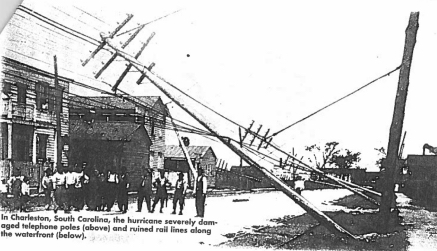
Great Hurricane of 1911
The Great Hurricane of 1911 was a gamechanger for Charleston. It made landfall Aug. 27/28 on Hilton Head Island as a Category 2 storm with winds near 100 mph. It was a reminder that every tropical storm has its own personality, so never underestimate a Cat 2. It moved slowly westward and weakened into a tropical storm before reaching Statesboro, GA. Wind gusts reached 110 mph in Beaufort, 96 mph in Savannah, 95 mph on Edisto Island, and 94 mph at Charleston, SC (before the Weather Bureau's anemometer broke) causing many trees, power lines, and telegraph lines to fall. A significant storm surge produced extensive flood damage, especially from around Beaufort to Charleston. With a storm surge that pushed salt water up into the Lowcountry rice dikes, the Greaet Hurricane of 1911 was the last nail in the coffin of the floundering rice industry, effectively ending the economic engine that had long made Charleston among the wealthiest areas in North America. Smashing boats and docks, it also took a toll on the fishing industry of the Mosquito Fleet.
1912
This tropical storm moved southwest off the South Carolina coast on Sept. 5 before weakening into a tropical depression and making landfall on Ossabaw Island, Ga.
1913
This Category 1 hurricane made landfall on Cape Island near McClellanville, just north of Charleston on Oct. 7. Over the next three days it produced up to 4 inches of rainfall on Charleston and even more in the Pee Dee area of the state.
1916
A tropical storm that blew in on Fripp Island May 15-16, making it the earliest landfalling tropical storm to hit before the Charleston Hurricane, caused flooding both along the coast and inland.
1916, The 1916 Charleston Hurricane
Just as the earliest arriving tropical storm had occured two months before, on July 14, the earliest Category 2 storm in state history came ashore at Bulls Bay/Awendaw, with winds estimated at 105 mph. Heavy rainfall drenched the Pee Dee region of the state, with 13.25 inches falling in Effingham. Damage, which has been estimated at $282 million (in 2023 dollars) and destroyed more than 700,000 acres of cropland, was most significant north of Charleston. It was probably the worst damage in that area since the 1822 hurricane.
1925
The latest tropical storm ever to impact South Carolina came ashore Dec. 2.
1927
This unnamed tropical storm made landfall between Edisto Beach and Seabrook Island on Oct. 2/3.
1928, The Lake Okeechobee Hurricane
Making landfall between Beaufort and Charleston as a Category 1 hurricane on Sept. 18, this storm downed trees and utility lines. Charleston alone is estimated to have suffered $1 million in damage.
1940, The 1940 South Carolina Hurricane
This category 2 hurricane made landfall on Daufuskie Island near Hilton Head on Aug. 11, with winds at 105 mph. Trees and roofs were damaged 50 miles inland. Parts of the Lowcountry recorded 10 inches of rain, with its storm surge damaging property from Folly Beach to the U.S. Marine Corps base on Paris Island near Beaufort. The tidal surge at Charleston was 10.71 feet. Crops losses including corn, hay, cotton and produce, were severe in along the state's coast.
1945
This unnamed tropical storm came in at Jones Island, which abuts the state line between South Carolina and Georgia, on Sept. 17.
1952
An unnamed tropical storm came in at Myrtle Beach on Aug. 28, with little impact on Charleston.
1952
Just two days later, however, Hurricane Able, a Category 2 storm, came ashore on Pritchard's Island near Beaufort Aug. 30.
1954, Hurricane Hazel
Because it came ashore in Horry County, Charleston did not experience the catastrophic damage felt to those living in Georgetown and above. At Category 4, Hazel was the latest and the strongest storm to make landfall in South Carolina, coming ashore near Little River, near the S.C./N.C. state line on Oct. 15. With windspeeds up to 130 mph only two of the 275 buildings in Garden City were left standing. She remains the largest hurricane to hit this far north. It caused 95 deaths in the United States and is considered one of the worst storms on record in South Carolina.
1958
The earliest Category 4 storm to make landfall in South Carolina came ashore Aug. 26.
1959, Hurricane Cindy
The first of two significant storms in 1959, Hurricane Cindy, a Category 1, made landfall July 4-9 just north of Charleston, near Bulls Bay, with winds near 75 mph. 64 mph winds were recorded at McClellanville along with 1 death. Storm tides were about 4 feet above normal and heavy rain fell.
1959, Hurricane Gracie
One of the Lowcountry's largest storms, Category 4 Hurricane Gracie made landfall Sept. 28-30 on St. Helena's Island with sustained winds near 130 mph. The storm surge in Charleston Harbor was between 9 and 10 feet, but would have been much worse if the storm had hit at high tide instead of low tide.The highest recorded storm tide was about 12 feet above mean low water at Edisto Beach. Rainfall totals were above six inches were recorded along the storm's path.
The relatively slow storm tracked north-northwest
through the Midlands, maintaining hurricane
strength before weakening to a tropical storm over
Chester County, causing extensive wind and flood damage across South Carolina, especially in the Beaufort to Charleston corridor. Gracie destroyed crops in the
Lowcountry and Midlands, including a significant
loss of the unpicked cotton crop.
Ten deaths in Georgia and South Carolilna were attributed to Gracie.
1960, Hurricane Donna
Hurricane Donna first hit Florida Sept. 11 as a Category 4 storm, then weakened to a Category 1 before strengthening again to a Category 2 off the Carolina coast. Though the eye of the storm did not hit Charleston, winds from its outter edges as it passed by the Lowcountry spurred tornados in the area. Today Hurricane Donna is probably best remembered in Charleston as the storm that caused a tornado that destroyed all but the western fascade of the Bennett Rice Mill off Concord Street.
1968
Hurricane Gladys dropped 13.80 inches of rain on inland Marion, Oct. 17-20, the tenth highest amount in state history.
1971
A unnamed tropical storm, T.S. Eight, dropped 14.11 inches of rain on Sullivan's Island Aug. 15-18, the eighth highest amount in state history.
A second tropical storm came ashore at Charleston on Sept. 10/11, though it quickly dissapated.
1976, Hurricane Dottie
Dottie came ashore at Charleston on Aug. 19-21 as a tropical storm before dissapting near Lake Moultrie.
1979, Hurricane David
David made landfall on Sapelo Island, Ga., as a Category 1 hurricane with winds of 90 mph. He produced at least five tornadoes, heavy rainfall, significant storm surge and beach erosion, and $10 million in damage in South Carolina.
David was my first storm and I loved seeing the waves arch over High Battery (yes, I foolishly went out in the storm to see for myself).
The College of Charleston evacuated its remaining student body to high ground at The Citadel. My roommate and I, both of whom had been to a hurricane party the night before, slept through the evacuation. Instead our boyfriends picked us up at the last minute and ferried us to the residence of my roommate's boyfriend's grandmother's house up on Rutledge Avenue, high ground. (Unfortunately the lady had recently passed away and her house still had some food items, toilet paper, napkins, etc. Several other fraternity guys joined us there for what turned out to be an amazing hurricane party as we watched the wind and the rain batter the city like nothing I had ever seen before.
1981
A tropical depression moved north along the Florida east coast, making landfall on Fripp Island on July 3.
1985, Hurricane Bob
This Category 1 hurricane made landfall on Fripp Island July 24/25, producing a 48 mph gust at Folly Beach. Five inches of rain fell at the Charleston Airport.
1988, Tropical Storm Chris
Chris came ashore on James Island Aug. 28.
1989, Hurricane Hugo
For those of us in this generation, this was the Big One, the one we all have stories about, the one that sets the standard for what a "real" hurricane is. Most scholars agree, Hurricane Hugo was one of the worst natural disasters in South Carolina's history.
At midnight Sept. 21/22, the eye of Hugo, a Category 4 storm, passed over Cove Inlet between Sullivan's Island and Mt. Pleasant, taking out the old Pitt Street bridge that once connected the island to the mainland by trolley. With sustained winds near 140 mph, it was moving about 25 mph to the northwest. Because of this speed, Hugo maintained hurricane-force winds (74 mph or higher) as far inland as Sumter, where gusts reached 109 mph. Gusts reached 87 mph in Charlotte, NC. The peak wind gust in downtown Charleston was 108 mph, at Folly Beach 107 mph, and at the airport 98 mph.
Making landfall just before high tide, Hugo produced the highest storm tide height in history along the U.S. East Coast, around 20 feet in Bulls Bay near Cape Romain and McClellanville and 10-12 feet above mean sea level in Charleston Harbor. Rainfall was limited by the speed of the storm, although up to 10 inches fell throughout southeast South Carolina, with the highest level being 10.28 inches at Edisto Island.
Hugo produced huge damage throughout the Lowcountry and well into the interior of the state, Forested areas in 36 counties along the storm’s path sustained significant damage. Hugo remains the costliest storm in South Carolina history. At the time, it was the nation's costliest
hurricane, as it caused about $17.2 billion (inflation-adjusted to 2023) in damage.
1994, Hurricane Beryl
Hurricane Beryl dumped 17.45 inches of rain on Jocassee Aug. 13-18, the second highest amount measured in South Carolina.
1995, Tropical Storm Jerry
Jerry made landfall Aug. 24-27 at Palm Beach, Fla., before hugging the coastline of the South Atlantic Bight. Though the storm dissapated northwest of Augusta, Ga., Charleston recieved 7 inches of rain at the airport. Hilton Head recorded 15.13 inches of rain, the sixth highest amount on record in the state.
1999, Hurricane Floyd
Floyd was a large and intense Cape Verde storm that pounded parts of the Bahamas and threatened the entire Southeast U.S. coast, with Charleston predicted as its bulls-eye for its last few days. Floyd neared a Category 5 intensity in the Bahamas, though weakened to a Category 2 as it bypassed Charleston and made landfall near Cape Fear, NC. Though a near miss for Charleston, the storm produced an 85 mph gust and 4 inches of rain downtown. At its peak, Floyd dropped 16.8 inches of rainfall in South Carolina, the fourth highest amount in the state's recorded history.
S.C. Gov. Jim Hodges' decision to not reverse the eastbound lane of I-26 in Charleston led to the largest traffic jam in the state's history. I was the last car in it, requiring four and a half hours to travel from James Island to the North Charleston Coliseum.
2002, Tropical Storm Kyle
Kyle moved north-northeast along the GA/SC coasts before making landfall near McClellanville on Oct. 11/12 as a tropical storm. It produced heavy rainfall across coastal southeast South Carolina, measuring 4.91 inches at the Charleston Airport.
2004, Hurricane Charley
Charley came ashore as a Category 1 storm at Cape Romain Aug. 14. It produced a peak wind gust of 38 mph and 1.02 inches of rain at the Charleston Airport.
2004, Hurricane Gaston
Just two weeks after Hurricane Charley, Hurricane Gaston followed nearly the same path, coming ashore at Awendaw on Aug. 28 as a Category 1 storm. Gaston produced a peak wind gust of 55 mph at the Charleston Airport and 4.63 inches of rain downtown.
2005, Hurricane Frances
Originally a Category 2 storm making landfall in Florida, then dropping down to a tropical storm as it made a second landfall in that state, Frances affected the Lowcountry by spawning an estimated 20 tornados,
2016, Tropical Storm Bonnie
Days before the official start of hurricane season, Bonnie developed north of the Bahamas and strengthened into a tropical storm as it moved northwest toward the GA/SC coasts, eventually weakening to a tropical depression before making landfall May 28 near Charleston. The storm produced 3 to 7 inches of rainfall across the Lowcountry, with local amounts exceeding 10 inches, leading to significant flooding.
2016, Hurricane Hermine
On Sept. 1-3, Hurricane Hermine dropped 14.17 inches of rain on Georgetown, the seventh largest amount in state records.
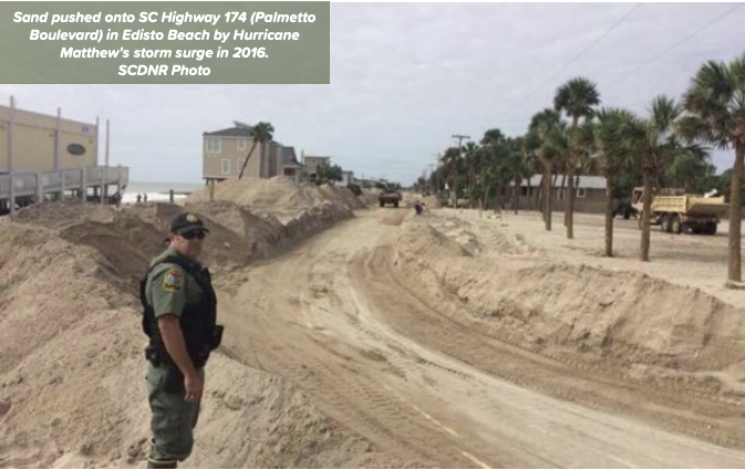
2016, Hurricane Matthew
Just a month after Hurricane Hermine, on Oct. 7/8 Hurricane Matthew dumped 16.92 inches of rain on Edisto Island, the third highest state record. Matthew began as a monster storm, a Category 4 as it moved through the Caribbean Sea and Bahamas. By the time it came ashore at McClellanville, it had weakened to a Category 1 with winds near 85 mph. The storm produced hurricane force wind gusts along the state's entire coast, with significant coastal flooding from high storm tides and very heavy rainfall (widespread 6 to 12 inches with locally higher amounts near 17 inches) leading to significant freshwater flooding.
2018, Hurricane Florence
Making landfall near Wrightsville Beach, N.C., Sept. 15-18 as a Category 1 storm, Hurricane Florence then shifted southwest into the Myrtle Beach area as a tropical storm, dumping 23.68 inches of rain in Loris, a state record. Charleston saw tropical storm force wind gusts and heavy rain, though no significant impacts were recorded.
2019, Hurricane Dorian
Hurricane Dorian, originally a Category 3 storm, moved northward off the South Carolina coast, dropping 15.21 inches of rain on Pawley's Island Sept. 5/6, the fifth highest amount in the state's history. Weakening to a Category 2, the storm produced sustained tropical force winds, hurricane force wind gusts, and significant coastal flooding.
2020, Tropical Storm Bertha
Bertha developed just off the SC coast and made landfall near Isle of Palms May 27 as a Tropical Storm. It produced heavy rain and minor wind damage.
2020, Hurricane Isaias
On Aug. 3, Hurricane Isaias skirted just off the GA/SC coasts as a tropical storm before strengthening to a Category 1 hurricane 50 miles east of Charleston. It produced tropical force wind gusts and heavy rain, mainly northeast of Charleston.
2021, Tropcial Storm Danny
Making landfall on Pritchards Island June 28 as a weak tropical storm, Danny produced 3 to 6 inches of rain, causing some flooding.
2022, Tropical Stor Colin
This tropcial storm made landfall on Hunting Island July 1.
2022, Hurricane Ian
Ian took many by surprise with a pretty big punch for a relatively low-rated storm. This Category 1 hurricane came ashore at Georgetown on Sept. 30, 2022, impacting the Lowcountry with strong gusty winds and torrential rainfall, producing several flash flooding events.
2023, Tropical Storm Idalia
On Aug. 30, Idalia moved from the northeastern Gulf of Mexico region up through southeast Geogia and southeast South Carolina before exiting back into the Atlantic south of Myrtle Beach. Tropical storm force winds battered the Georgia and South Carolina coastline, and heavy rain fell across inland areas west of the Interstate-95 corridor, causing inland flooding. The storm's passage coming with a high tide resulted in a damaging storm surge across portions of the state's coast.