MORRIS ISLAND
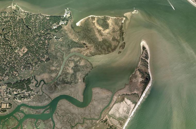
Occasionally a uniform button, belt buckle or dangerously unexploded piece of ordnance washes up along Charleston’s beaches. Other than such surprises, however, not much remains of a small spit of sand where thousands sacrificed their lives during the Civil War.
When Europeans arrived in 1670, they discovered two channels through which large ships could reach the mainland: one ran along Sullivan’s Island to the northeast of the harbor’s entrance and the other adjacent to three small islands on its southern edge, named Cummins, Morrison and Middle Bay. By 1673, colonists built their first navigational signal on the middle of those three southern islands. That first “lighthouse,” to use the term loosely, was basically a fireball made of oakum and pitch hanging from an elevated iron basket.
By 1767 John Morrison had cultivated a thriving farm on the island with crops and livestock. Around the same time, King George III ordered the construction of a 42-foot tall lighthouse to replace the fireball. This beacon was heavily damaged during the American Revolution, after which Morris sold the island. By 1800, the three islands had merged into one, thanks to the natural processes of ever-shifting sands, and its name was shortened to Morris Island.
In 1838, Charlestonians built the second of three lighthouses here. Over time at least 15 other buildings were constructed to support the full-time, on-site light keeper and his family. Among them were three Italianate cottages, a small schoolhouse and a boathouse, as well as a large residence that was called Beacon House. For generations, light keepers and their families lived there.
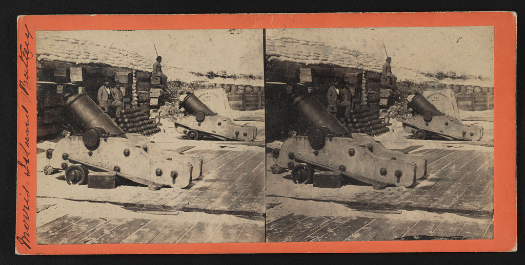
Morris Island earned its place in history as what is traditionally believed (though sometimes disputed) to be the first shot of the Civil War was fired from Cummings Point on its northern tip. Fort Sumter controlled access to Charleston, and Morris Island controlled access to Fort Sumter, making it a key strategic asset. Both Confederate and Union troops built forts and batteries here in an effort to control the island and its lighthouse, with its commanding view of the harbor.
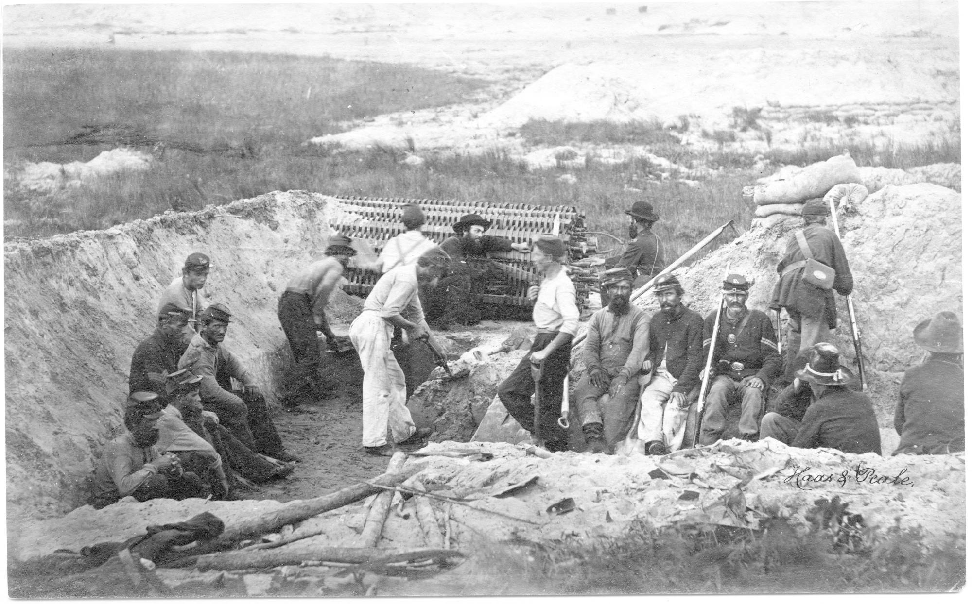
Though a number of battles, two of them major, occurred here, the island may be best remembered today as the site where some of the first African Americans to bear arms in the U.S. Army stormed Battery Wagner. In the opening days of the Civil War, Confederate forces did not arm African Americans for obvious reasons. Even the North eschewed arming free Blacks and escaped slaves anxious to help free the South, expressing concerns over whether they had the skills and courage necessary for battle. Yet after an enslaved harbor pilot named Robert Smalls stealthily maneuvered a fully armed Confederate ship, filled with his African-American crew and their families, through the Charleston Harbor blockade to freedom, northern leaders gained new respect for what these men were capable of, and created several African-American military units.
On July 18, 1863, 650 members of the all-black (except for Col. Robert Gould Shaw) 54th Massachusetts regiment lined the shores of Morris Island. After one of the bloodiest battles of the Civil War, Confederate forces claimed victory. Eyewitness accounts say the entangled bodies of black and white soldiers lay three deep. Despite having lost nearly half their number, however, the soldiers of the 54th Massachusetts had won a different kind of victory: they had clearly demonstrated the skill, bravery and tenacity of which they were capable.
Beacon House bore the brunt of shelling from both sides during the Civil War. Morris Island fell to Federal troops in 1863, and Gen. W.H. Davis of the 104th Pennsylvania Infantry established his headquarters there. It was later used by Gen. Quincy Adams Gillmore as a signal station. Using “glasses” (as early binoculars were called) from the house’s cupola, soldiers could clearly see the movements of downtown Charlestonians. Over time, however, soldiers began to strip the house for firewood and other purposes.
The Rev. Frederic Denison, chaplain of the 3rd Rhode Island Heavy Artillery Unit, wrote in his 1879 memoir, Shot and Shell:
“How many soldiers will recall the old Beacon House, near the centre of the island, from which we quietly detailed the floor-boards and sheathing till only the frame and roof were left, and from the cupola of which, was a look-out station, with our glasses we could read the time of day on the faces of the town clocks in Charleston, and discern the people passing in the streets. Two men were constantly kept as observers and signal officers in the tower of this building, till finally, from depletion of material, the remaining skeleton succumbed to a southern gale.”
A third lighthouse was built in 1876 about 1,200 feet above the high tide mark, and with it new supporting structures, including the keeper’s residence. Soon afterward, maritime officials petitioned Congress for funds to build jetties at the harbor’s entrance, which would constrict the flow of silt into the harbor and help deepen the shipping channels for commerce purposes. While jetties improved the channels, they also altered the natural progression of sand migration to both Sullivan’s and Morris islands. The islands began shrinking from the erosion.
Congress then appropriated funds to create “spurs” (perpendicular wings) on the jetties that would help protect the islands’ coastlines. The northern spurs were completed and Sullivan’s island protected. The southern jetty’s spur, however, was never completed. By 1938, it had become clear that as the ocean’s waves encroached upon the eroding island, the lighthouse would have to be automated and all the other buildings removed for safety’s sake. Had they been left to simply wash away, the debris would have posed a hazard to mariners. Though the other structures were simply torn down, Beacon House was sold to Dr. Richard Prentiss as federal surplus property for $55. Beginning with its roof, workers spent four weeks dismantling the residence. Dr. Prentiss used most of the salvaged material to build two beach houses on Edisto Beach. Unfortunately both were washed out to sea in later hurricanes. A steel barrier around the lighthouse’s base braced it from toppling into the now-surrounding ocean.
When the Sullivan’s Island Lighthouse was completed in 1962, the Morris Island Lighthouse was decommissioned and sold to a private buyer. Over the next 30 years, the island would gain, then lose, sand, depending on weather and other coastal dynamics. By 1992, the island had recovered 80 acres of dry land, and a developer sought permits to build houses on it. Charlestonians were horrified at the prospect and in 1999 a nonprofit group, Save the Lighthouse, purchased the site and began seeking ways to preserve it. Their work has kept the tower upright, but its light remains dark, perhaps forever.